To the West with the Milligans, 2017
Westward Daily Journal
On this page before the journey we will post what we plan to see and do each day on the way to Glacier National Park. During and after the journey we will post what we did.
Sunday, July 31
We did a test drive of our new tent at Cherokee Dam. This was a good idea. We learned that we needed a few more tent stakes - there weren't enough included with the tent to use all the guy lines - which we think it needed. We also need a tent light so we don't have to use our headlamps. We forgot to pack the rubber mallet for driving stakes. All in all it was pretty comfortable sleeping on the cots with the new sleeping bags and camping pillows. The little fold able tables we ordered from Walmart were very helpful.
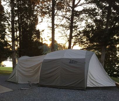
The front part of the tent (left side in this picture) is called the garage and it doesn't have a floor. The sides of the garage can be opened out or rolled up. It fits our chairs and our new fold able table. It will be a nice place to sit and remove shoes before going into the tent. It also makes it easy to keep the screens on the tent doors open and have privacy. The tent is just the part in the center with the darker rainfly. The back part is part of the rainfly that makes a vestibule. We probably won't use this part too much since we bought the garage section at the front. We also practiced how we will pack everything in the car and I think we have a good system that lets us get to things we need easily.
We did a test drive of our new tent at Cherokee Dam. This was a good idea. We learned that we needed a few more tent stakes - there weren't enough included with the tent to use all the guy lines - which we think it needed. We also need a tent light so we don't have to use our headlamps. We forgot to pack the rubber mallet for driving stakes. All in all it was pretty comfortable sleeping on the cots with the new sleeping bags and camping pillows. The little fold able tables we ordered from Walmart were very helpful.
The front part of the tent (left side in this picture) is called the garage and it doesn't have a floor. The sides of the garage can be opened out or rolled up. It fits our chairs and our new fold able table. It will be a nice place to sit and remove shoes before going into the tent. It also makes it easy to keep the screens on the tent doors open and have privacy. The tent is just the part in the center with the darker rainfly. The back part is part of the rainfly that makes a vestibule. We probably won't use this part too much since we bought the garage section at the front. We also practiced how we will pack everything in the car and I think we have a good system that lets us get to things we need easily.
Monday, August 21
We will pack up and travel through Kentucky, Indiana, and Illinois. It will probably be our longest day of just driving and the most miles in a day, 560 miles. This is the day of the total solar eclipse so we will probably stop along the way somewhere to see it. We will change time zones this day from EST to CST. We will stay at the Baymont Inns and Suites, Normal Bloomington.
We will pack up and travel through Kentucky, Indiana, and Illinois. It will probably be our longest day of just driving and the most miles in a day, 560 miles. This is the day of the total solar eclipse so we will probably stop along the way somewhere to see it. We will change time zones this day from EST to CST. We will stay at the Baymont Inns and Suites, Normal Bloomington.
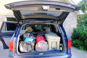
After several re-arrangements we got the car packed with a workable arrangement and left the house at 9:00. It was exciting to make our plans reality.
|
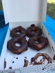
Our first stop was in Knoxville at the Krispy Kreme to get the special chocolate eclipse donuts.
We drove up I75 to Lexington, Kentucky. We stopped for lunch at a rest stop between Lexington and Louisville. There was a couple there also having a picnic lunch who shared their solar eclipse glasses so we saw it at about 50% covered. It really never got dark, just a strange shade of orange - more like a sunset. We stopped at the Indiana welcome center and ate supper in Crawfordsville, Indiana. We stopped at the Illinois Welcome Center. We made it to our hotel in Bloomington, IL at 8:00EST, 7:00CST. We drove 560 miles today. |
We drove through mountains, cities, and finally flat farmland. We only a light rain in Indianapolis.
Tuesday, August 22
Another long day of driving this day, 500 miles across Iowa and into South Dakota. We will still be on CST. We will stay in a camping cabin at the KOA in North Sioux City, SD. We will still be on CST.
Moon Phase: New
What We Did
We began the day in Normal Illinois. It was lightly raining. We stopped at the first rest stop in Iowa and got a map - and it was a good thing we did. We had to go through downtown Peoria because the loop was under construction - at rush hour in rain. As we continued on I-80, the traffic and the big trucks just got heavier. It was very difficult driving so we decided we would take another route. Thomas was a great navigator and with the help of the Iowa map and the GPS we found a much less stressful and more scenic route.
At Iowa City we headed north towards Cedar Rapids where we got on Highway 30. What we didn’t know at the time is that highway 30 is called the Lincoln Highway and is a scenic highway. It was some 4 lane divided highway, but mostly 2 lanes. We sill made good time. There were many beautiful barns and windmills. I found one on the side of the road that I could easily photograph. Even though there are no mountains, the sky became clear blue with white fluffy clouds. There is a different kind of beauty here, sky and corn fields as far as the eye can see.
We ate lunch in Marshelltown. While navigating, Thomas found a reference to the Mahanay Bell Tower in Jefferson Iowa. It is a carillon with 2 octaves of bells that are controlled by a digital keyboard. We rode up the elevator to the top of the 128 foot bell tower with a view of the surrounding communities. We toured the county courthouse with a beautiful stained glass dome.
We traveled on toward our destination of North Sioux City, SD on mostly 2 lane roads. We did have a slight construction delay of about 20 minutes due to road construction. We traveled a total of 493 miles today, which is actually less then had we traveled the Interstate all the way.
Wednesday, August 23
Plans
This day will be our first real sightseeing day. We will move from CST to MST. After a morning 5 hour drive, 350 miles, we will tour the Badlands National Park. We will begin with the Ben Reifel Visitor Center. There are two short nature trails close to the visitors center: Cliff Shelf Nature Trail (.5 mile loop) and Notch Trail (1.5 mile loop). Afterwards we will continue on the Badlands Loop Road with several overlooks along the way.
Average temperature on this date 57° to 87°
The next stop will be Mt. Rushmore National Monument, 100 miles to the west. There are several trails that leave from the visitor's center. There is a light show at 8pm. It is only about 20 miles to Custer State Park where we will be camping. Depending on how long we spend in the Badlands we may go on and set up camp and then come back to see Mt. Rushmore light show.
Sunset at Mt. Rushmore: 7:44pm at 286.2°
What We Did
We began our day by finding the South Dakota visitor's center and got our state map. We made some changes for our day based on a conversation with the employee there. We decided to stop in Mitchell and visit the Corn Palace. We traveled on to the Badlands. We got there in the middle of the day so the light was very harsh and it was extremely hot. We did do a short hike, the Cliff Shelf Nature trail - even though it was only (.5 mile loop)it was a really difficult trail due to heat and climb. We did take the loop and stopped many times. It was beautiful in its own way. After leaving the Badlands we did stop at Wall Drug - which can best be described as Pigeon Forge and Gatlinburg compressed into 2 blocks.
We arrived at Custer State Park at 7:00 and got the tent put up in about an hour - just before dark. We had a nice spot by a little creek - but it was a little far to the bath house.
We drove 476 miles this day.
Thursday, August 24
We will spend the day visiting Custer State Park. We will begin with a stop at the visitor's center and plan our day. If time we can either go to Wind Cave National Park or Jewel Cave National Monument which are close by. Another option is the Crazy Horse Memorial.
Average temperature on this date: 49° to 77°
Sunrise: 6:08 am at 73.5°
Sunset: 8:00pm at 285.9°
What We Did
Custer State Park and Mt. Rushmore
We began the day by driving on the Needles Highway. This 2 lane road travels through rock formations called Needles. There were several one lane tunnels that were hand hewn out of rock. There was a beautiful lake on the road.
Custer State Park and Mt. Rushmore
We began the day by driving on the Needles Highway. This 2 lane road travels through rock formations called Needles. There were several one lane tunnels that were hand hewn out of rock. There was a beautiful lake on the road.
We then traveled to Mt. Rushmore. On the way back we went on Iron Mountain road which is very similar to the Needles Highway. The road was designed with tunnels that would give a view of Mt. Rushmore through the tunnels
Friday, August 25
We will begin this day by seeing sights on the way to our next stop, Greybull, WY. Depending on what we saw on Thursday we will begin this day by seeing Crazy Horse or Jewel Cave. We will travel on the Big Horn Scenic Highway and see high mountain views and Shell Falls along this scenic Wyoming highway. We will stay in a Camping Cabin at the KOA. We will drive 314 miles.
Sunrise: 6:10am at 74.5°
Sunset: 7:56pm at 284.9°
Average Temperature on this date: 52° to 87°
We left Custer State Park and at the suggestion of the Information Office we decided to make a detour from our planned trip to see Devils' Tower. (While we did drive past Wind Cave and Jewel Cave it would be lunch time before we could get in a guided tour of either one which would put us very late driving on the Big Horn.) This amazing formation was formed by a volcano. It is a special place for Native Americans and also rock climbers. It was fascinating to see them climbing.
We drove on through Wyoming and had a steak dinner at a famous steak house, R&B Chop House in Gillette, Wyoming. We drove on to the Big Horn Scenic Highway. I had been very excited about seeing this highway from reading about it, but was disappointed when we ran into rain. There was also a lot of construction and even part on a dirt road. Shell falls was closed and we were unable to see them. While we didn't see what I had hoped and read about we did see a beautiful rainbow and had a nice sunset on an amazing road. We stayed in a camping cabin in Greybull and had a good night's sleep at a very nice KOA.
We drove 397 miles today and a total of 2004 miles for the trip so far.
We drove 397 miles today and a total of 2004 miles for the trip so far.
Saturday, August 26,
We will head to Great Falls, MT through the Big Horn Canyon National Recreation Area and see Greycliff Pairie Dog Town State Park along the way. We will drive 336 miles.
Average Temperature on this date: 52° to 87°
Sunrise: 6:28am at 74.8°
Sunset at Great Falls: 8:16pm at 285.8°
We will head to Great Falls, MT through the Big Horn Canyon National Recreation Area and see Greycliff Pairie Dog Town State Park along the way. We will drive 336 miles.
Average Temperature on this date: 52° to 87°
Sunrise: 6:28am at 74.8°
Sunset at Great Falls: 8:16pm at 285.8°
We had such a good nights sleep that we slept until 6:30, which is 8:30 EST. We also took time to replace the ice in the cooler and replace some supplies at the grocery store. We didn't leave until 10:00. We drove mostly on long, straight, 2-lane roads through the high plaines. It wasn't the big sky that we expected to see because of all the fires in Montana. The sky was smoky and you could only dimly see the high mountains. It is hard to get used to the fact that the speed limit on these 2 lane roads is 70 mph. We drove onto Great Falls Montana. We stopped first at the Lewis and Clark Interpretive Center.
Today we drove 342 miles.
Today we drove 342 miles.
Sunday, August 27
We will visit the Lewis and Clark National Historic Trail Interpretive Center and the C.M Russel Art Museum. We will tour the town by taking River Drive with several parks along the Missouri river. After touring we will travel on to Glacier National Park to meet up with DeeDee and Bret at Logan's Pass Visitor's Center, 200 miles northwest.
Average Temperature on this date in Great Falls: 48° to 79°
Sunrise: 6:34am at 72.8°
Sunset at Logan Pass: 8:25 at 285.6°
We visited the Lewis and Clark Center on Saturday. We did enjoy the C.M. Russell museum and the river drive on Sunday before heading west to Glacier. On the way to Glacier we drove around the south of the park and entered on the West Side instead of going over the the Going To the Sun Road.